India Meteorological Department (IMD) grided data to GeoTIFF
Update [27 Feb 2021] For latest documentation, please visit https://imdlib.readthedocs.io/en/latest/ Now, you can convert the IMD dataset to GeoTIFF using d...

Just some thoughts!
Update [27 Feb 2021] For latest documentation, please visit https://imdlib.readthedocs.io/en/latest/ Now, you can convert the IMD dataset to GeoTIFF using d...
Update [27 Feb 2021] For latest documentation, please visit https://imdlib.readthedocs.io/en/latest/ Description IMDLIB is a python package to download and ...
Go to this site: How to pick more beautiful colors for your data visualizations?!
The Weather Research and Forecasting (WRF) Model is a mesoscale numerical weather prediction system utilized worldwide for operational forecasts and research...
A simple and elegant method to convert NetCDF to GeoTIFF using python. Python Script import xarray as xr import rioxarray as rio #Open the NetCDF #Download...
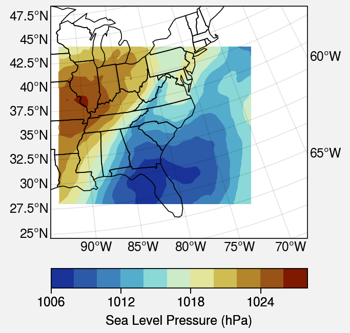
Here is an example of generating a surface plot from WRF output file. I find this method to be more elegent. Python Script import wrf from netCDF4 import Da...
The Weather Research and Forecasting (WRF) Model is a mesoscale numerical weather prediction system utilized worldwide for operational forecasts and research...